Welcome

I really started The Outdoor Gems to share outdoor experiences through photography and storytelling to inspire more people to get outside. If more people got outdoors; took a walk, hike, went snowboarding, sat around a campfire, and surfed in the ocean, I think the world would be a better place.

-Jeremiah

The Latest

Jer A Jer A

Taking a Trip to Moab Utah, the Ultimate Desert Guide

There’s just something about the desert that is intriguing. It’s much different than anything you’ll experience. Red clay, desert sunsets, giant rock structures, and vast canyons that will make one really appreciate this planet. There’s a lot of things to do in Moab inside and outside the National Parks from hiking to sky diving, riding dune buggies, fishing, and even rafting on the green river. My favorite thing is to hike and explore national parks so that’s what

Disclosure: When you buy something through the Affiliate product links I have created below, I earn a small commission. I only promote products and companies I support as well as believe in.

There’s just something about the desert that is intriguing. It’s much different than anything you’ll experience. Red clay, desert sunsets, giant rock structures, and vast canyons that will make one really appreciate this planet. There’s a lot of things to do in Moab inside and outside the National Parks from hiking to sky diving, riding dune buggies, fishing, and even rafting on the green river. My favorite thing is to hike and explore national parks so that’s what I’ll be going over in this post with one hike I did outside of the park.

I’ll be going over where to stay in Moab, how to get there, park information, favorite photo spots, and areas that I explored and are worth checking out.

Where is Moab

Located on the east side of Utah near the Colorado border, it’s just under 4 hours to Salt Lake City and just under two hours to Grand Junction Colorado. The two closest major airports will be in Salt Lake and Grand Junction as well. There’s a couple ways to get to Moab, with the main route being off I-70. No matter which route you drive you’ll end up on US-191 to get to the town of Moab. Below I listed distances and average times from major areas.

Breckenridge: 293 miles/4 hours 30 minutes

Grand Junction: 112 miles/1 hour 45 minutes

Salt Lake City: 234 miles/3 hours 45 minutes

Denver: 354 miles/5 hours 30 minutes

A view from above as you enter Moab
Blue hour driving through Arches
Big canyon walls as you drive into the park

What makes Moab so special

The desert is a unique place especially in Utah. There are huge rock structures that were created millions of years ago from erosion and mother nature. All of these formations were done gradually and what we see currently is just a blink in the grand scheme of time, so all in all, it is fascinating to hike or walk around these areas.

A small cactus
Looking up at The Windows Arch
Garden of Eden

What caused these rock structures to form

Lots of little changes over millions of years as the ocean came and left, mountains were formed and disappeared, essentially causing erosion, shaping the rocks we see today. There’s a lot of theories on what caused them, and as time goes on more data is discovered allowing scientists to form reputable conclusions.

Should we visit both National Parks

I would highly recommend going to both, at least for a day each. There’s no longer a reservation system to get into Arches which is nice. Arches will be the closest park and is going to be more rock formations and structures, where as Canyonlands is still rock structures, but as the name states it will be vast Canyons and valleys.

Blue hour at Arches in the AK Burton puffy
A secret spot to view Delicate Arch

What is parking like in the parks

Some of the more popular parts of each park will have plenty of parking, whereas the stops along each area will have limited parking. Sometimes you just have to wait for a vehicle to move or you can always come back at a later time. Holiday weekends and in the spring as well as fall will be the busiest times making parking more challenging! Keep in mind, early mornings and late afternoons are when finding spots will be easier!

Golden hour
smaller parking lots

When is the best time to visit

The best times to go to Moab are in the spring and fall from about March-May and September-October. I even think the winter would be cool as there wouldn’t be hardly any crowds. If you’re a photographer, the snow covering the desert would be a cool experience in my opinion. Although you probably wouldn’t be able to do any of the more challenging hikes because of ice and snow, just driving through the park would be a different experience. Hard to believe, but Moab does get snow in the winter months!

Are there any hikes that you would recommend outside the National Parks

Moab itself has a number of hiking and biking trails outside of the National Parks that don’t require you to pay a park fee. There’s a really cool hike about 40 minutes from downtown called Fishers Towers. It’s actually where a lot of western movies were filmed and even the famous show Westworld.

Hiking a trail in Utah
Huge canyon towers

This trail isn’t too challenging, but also isn’t easy. You essentially walk through the base of these giant towers that were formed 300 million years ago from sandstone erosion. At times there are steep drop offs and a number of switch backs with an elevation gain of 1,500 feet and 4.6 miles all together. I didn’t have service so I made sure to download the trail ahead of time on All Trails! This app is really helpful when doing hikes such as this.

At one point on the trail you’ll have to climb a ladder to continue your hike. At the top you’ll have vast views of the Onion Creek canyon area. The trailhead will start in a campground so if you see a series of camping spots, you know you are in the right area. A small parking lot can also be found at the trailhead.

Desert photography using the Canon R5
A scene where old western movies were filmed

H

The tallest tower is called the Titan and you might even see rock climbers throughout your hike trying climb these giant structures off in the distance, which to me is pretty wild. I probably wouldn’t take my dog on the trail just from all of the ups and downs and challenging areas. If you don’t have a map, use the stacked rocks for navigation. As always be cautious of falling rock as you hike up and back down the trail.

Where should we stay

There’s a number of hotels in downtown Moab that I believe will be your best option for lodging. My personal favorite was Gravity Haus. It wasn’t too expensive, restaurant on site, the rooms were nice, staff was welcoming, and it was walkable to downtown. Overall just a great place to stay.

nice living area in the hotel
excellent bedding options

Being close to downtown and Arches national park was pretty damn convenient when staying at this property. If you aren’t use to it, it’s different waking up in the desert. My room had a view of the landscapes which was nice each morning.

Gravity Haus members
The check in area

Are there campgrounds nearby

Yes there is plenty of camping inside of the national parks as well as close to Moab. I would get on Recreation.gov to reserve camp sites ahead of time. There’s also campgrounds outside of the park along the river such as Kings Bottom, The Ledge, and Hunters Canyon. The best camping I ever did in Moab was off of Kane Creek Road, about 30 minutes from town. It was primitive camping and you needed a higher clearance vehicle, but it was incredible. We would wake up surrounded by these vast canyon walls early in the morning for sunrise.

A campground in arches
 

Restaurants and coffee shops worth checking out

My favorite place to be honest was the food truck park and for coffee I really liked Más café. There have been a couple new coffee shops that have opened since I’ve been, that I’ve heard great things about such as The Press and Dos Mas. I would love to go back and check out again in the future! For breakfast I liked Cactus Jacks. If you want big portions and classic diner food, stop by Moab Diner.

For lunch or dinner I recommend The Spoke on Center or the Trailhead Public House and Eatery.

Plenty of seating in The Spoke
Beautiful coffee shop
The best coffee

One of the best salads we ever had was at the Moab Food Truck park at the fried chicken cart. It had a lemon vinaigrette that was chefs kiss.

Food Truck Park
Top breakfast in Moab Utah

What is the town like

The town has sort of this old fashion feel to it, with a number of shops and restaurants. If you’re looking for a souvenir, there’s plenty of stores with shirts, stickers, and collectibles to remember your trip at Moab. If you’re looking for a gear shop, go to Gearheads in Gravity house or Gear Trader. My favorite store in Moab is Desert Wild. It is more of a boutique store with outdoor clothing, hiking pants, footwear, and packs. It has a cool vibe on the inside!

The Moab Garage
Best Outdoor Gear stores
 

A golden retriever enjoying some fresh air on a warm spring day downtown. Looking for something unique and cool? The Cooper Martin Building below is where you will find The Spoke on Center restaurant. There’s a handful of businesses in historic buildings around Moab with this being one of them. The Moab Garage, a coffee and lunch restaurant was once a transportation company in the early 1900’s, getting locals to different parts around the country.

Golden Retriever sticking their head out a car window
historic building

Where should we go in Arches

The way Arches is set up is you can drive through the entire park stopping at different sites or you can hike some of the trails in the park. Wanting to do the different hikes will of course depend on weather and what you are up to for the day. My favorite hike and area to check out in Arches was Delicate Arch. This is of course one of the more popular areas, but the hike itself is awesome and the views are amazing in my opinion. I wrote a complete guide on the hike itself if you are looking for a more detailed guide.

Delicate Arch

An up close shot of the Arch

You’ll go through a number of geological layers of sandstone and rock on the hike, making the experience pretty unique. I saw families with kids doing it, so it is definitely doable!

Delicate Arch will be 3.1 miles out and back with a little over 600 feet of elevation gain. Make sure to bring plenty of water on this trail and I think the best times of the day to hike it would be for sunrise or sunset. The hike will start on a well marked trail, but once you get to the giant slab of rock you’ll have to follow signage and stacked rocks to get to the arch. This giant slab that you hike up is actually a collapsed salt dome which is why many of the areas are uneven. If you’re scared of heights, I probably wouldn’t recommend this trail as it can get really windy at the top and there are also some areas with drop offs.

Once you make it to the top, you’ll notice a number of people wanting to get a photo in front of the Arch, so be patient and considerate of others when taking photos!

Top photography angles of the Arch
Hiking up

Photo by Megan Ray

Balanced Rock

One of the first stops when you enter the park is Balanced Rock! The trail to see this feature is only .3 miles and it’s pretty much a flat walk. The larger rock sits on top of a more fragile base that will eventually erode with time. Try not to climb on these structures and just enjoy them from the path. This stop will have a small parking lot and it typically has spots since the hike isn’t very long.

incredible rock structures
An up close photo of Balanced Rock

Park Avenue

This will be the first stop in Arches with a viewpoint. You can either hike through these towering pillars or just stop for a quick view. I decided to hike the whole trail and it’s pretty flat the whole way. Towards the middle it really opens up and you’ll be surrounded by these towering structures. It’s about 1.8 miles with 322 feet of elevation gain, so it takes about an hour. If you go all the way to the end of the trail there is going to be a viewpoint of The Courthouse towers from the parking lot.

An easy hiking trail in Moab
Park Avenue viewpoint

North and South Window Arches

The windows arches area will probably be one of the most trafficked parts of the park from there being three different types of rock formations all within a small area. They are Double Arch, North and South Windows, and the Turret Arch. Although there is plenty of parking you might have to loop the lot a couple times to find a spot if you go during the day such as we did. The Windows will be on the same mile long loop as the Turret Arch, so you’ll be able to see all three.

It’s a fairly easy loop that will have two side trails, one being a viewpoint of the South Window and the second one being to Turret Arch. Both the North Window and Turret Arch, allow you to get up close to these structures! You’ll also be able to get canyon views on the other side of North Window.

Stairs to North Window
Viewpoint of The South Window

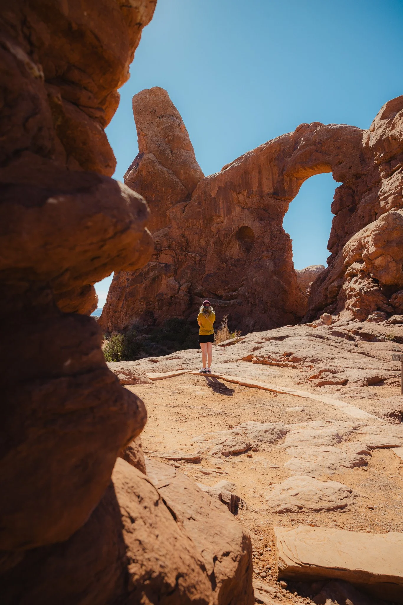
Turret Arch

A less marked trail, follow the signage and rock stacks to get here. Looking almost like a keyhole, Turret also allows you to walk through it and get up close to the arch. Follow the Windows loop back to the parking lot!

Walking around Turret Arch
detailed signage
A scenic photo of Turret Arch

Double Arch

If parking is busy you can park over at the Windows lot and walk over as this is probably one of the more sought out trails. When it’s busy you will see a number of people climbing and walking all over this structure, which made it challenging for photography. However if you go for sunrise or sunset, there shouldn’t be many people in the park just yet! Also if you plan on climbing to the lookout on Double Arch, make sure you are careful and watch your footing (this will make more sense once you are here)

Overlooking the Double Arch trail
looking up at the majestic part of this arch.

What I like most about Double Arch is how easy of a trail it is. Flat the whole way and only .6 miles, people of all ages are capable of seeing this awesome part of the park! Scientific theories are that water over a long period of time eroded the rock (pothole arches) and whatever other debris eventually also eroded the stone. Mother Nature truly humbles you at Double Arch.

Skyline Arch

This is when you are starting to get far into the park. If you are looking for another easy trail, Skyline is probably the best one! At only .4 miles out and back, it’s probably the easiest one in the park. It’s also not a very crowded one and you shouldn’t have any issues finding a parking spot, even though the lot is small. You can’t get too close to Skyline either so just enjoy the view from a distance

Skyline Arch shot on the Canon R5

Landscape Arch

If you’ve made it this far, you’ve probably seen most of the park by this point. I wasn’t as impressed with Landscape Arch as I thought I would be, but it was still a fun and easy-ish trek to get to. If you’re looking for easier hikes with kids, this will be a good one in my opinion. The trail is just under 2 miles out and back, starting off on a wide open sandy desert area. You’ll eventually start to walk through a tunnel like rock wall area until you reach the viewpoint of the arch.

The actual viewpoint area is somewhat narrow and will have a guard rail with other viewpoints as you approach the end of the trail!

With a decent size parking lot that has bathrooms too. Being this far from the entrance, it’s a nice place to take a quick breakl. An interesting fact is that this arch is the longest in North America.

Walking to Landscape Arch
Longest Arch in North America
walking through the tunnel area

Sand Dune Arch

Also not to far to get to this one at only at just .3 miles out and back. You hike through a thin wall to get to this one . It’s probably the most unique one in the park and kind of feels like you’re in a Start Wars movie. If you’re a photographer or videographer this is a cool one to get creative with!

Broken Arch

Located right next to the Sand Dune arch, there’s a trail that loops around through Broken Arch, a campground, and back to the same spot you started. If you don’t feel hiking the entire loop, no problem. You can hike to Broken Arch and back (just over one mile to do this). The entire loop is 2.6 miles including hiking to Tapestry Arch. I skipped that part due to timing but, ended up trekking the entire loop.

Along the way you’ll see more different kinds of rock structures and even go through a campground at one point. With only 292 feet of elevation gain it’s a pretty flat trail that is sandy and has lots of Utah desert plant life.

One of the unique rock structures near Broken Arch
Looking back at different rock structures in Oakley sunglasses

Should we stay in the parks for Sunset

For at least one of the nights you’re in Arches you should, especially if you like photography! The lighting is incredible and gives off a wild west feeling as the sun starts to set. There’s plenty of pullouts too throughout the park if you don’t feel like hiking to catch the last light of the day.

Capturing a happy moment at Arches National Park before the sun goes down
The most beautiful desert sunsets
Blue Hour in Arches

What about Canyonlands

I would at least check out Canyonlands for a day if you can. Since this is a different National Park, if you don’t have a yearly parks pass, you’ll have to pay a separate entrance fee that is good for up to 7 days!

Canyonlands itself has a lot of different areas and some of it is pretty remote according to the parks service I spoke to! Those areas require packing in lots of water and having a high clearance reliable vehicle. Just for reference, Canyonlands is 337,598 acres while Arches is 76,519 acres. But don’t let that deter you from exploring this area as there are still some awesome trails and overlooks. There are three parts to the park; Island in the Sky, The Maze, and The Needles.

I explored Island in the Sky as it was the closest to Moab and had areas that I had been wanting to check out for years. Below are ones that I would recommend if you only had one day here!

Aztec Butte

This was the first hike I did in the park to get my legs warmed up. At about 1.3 miles the trail can be somewhat confusing as you try to find the ancient structures. You honestly can really only see them from a distance and there’s also some smaller structures as you circle the very top area. Having a map is crucial on this hike as you’ll have to get on your hands and knees at times as you scramble towards the top of the hike.

BE AWARE of your surrounding as the trail has drop offs in areas.

a colorful Aztec Butte rock wall
A dry desert trail to start
Ancient Archeological site

To the left off the main trail will be an even smaller trail (look for signage) to two more archeological sites. I didn’t find it as interesting as the main trail. The vast canyon views at the top were honestly my favorite part and made the trek up worth it.

Steeper as you get to the top
Canyon rim views below

Mesa Arch

Probably one of the more popular areas in Canyonlands, Mesa Arch is an easy .6 mile loop and best hiked at sunrise as the arch has a glow to it in the early morning. I ended up doing it at golden hour in the evening and it was still beautiful. Since this is a more popular trail be respectful of others who also want to get photos and don’t get too close to the edge!

Golden hour at the Mesa Arch
An easy hike to get there
Stairs back to the parking lot

Upheaval Dome

Probably one of my favorite hikes I did in Canyonlands, just because of how unique it was. You essentially traverse up a giant rock path to two separate overlook areas. Unlike most of the park where rock formations were caused by years of erosion. Upheaval dome looks like it was caused by some kind of impact such as a meteor according to geologists.

The second overlook on upheaval dome
Hiking up in Nike trail shoes

The trail is going to be 1.3 miles with 229 feet of elevation gain (although it felt much greater). Hiking poles would help on the trail and follow the piles of rocks for guidance as you approach the peak! There’s going to be areas of this hike where you’ll need to get on your hands and feet as well as some up and down parts, where having good footing is crucial. Just always take your time and be cautious of your surroundings!

The first overlook of Upheaval Dome
The hike up a rock face of Upheaval Dome
<

Green River Overlook

The best way to end your day at Canyonlands is at the Green River Overlook! Make sure to stop here for sunset. The best part about this part of the park it is a short walk to the overlook from the parking lot. Bring a blanket too if you would like, as there are areas to set up and hangout.

The famous overlook in Canyonlands National Park

If you time it right on a good night, you may get some beautiful colors to end the day. It was honestly my favorite part of Canyonlands and makes you realize how small we really are in this world!

Red Canyon walls
Desert colors at sunset
wearing a warmer Burton AK jacket

What should we pack

Hiking footwear/shoes - I would recommend having some kind of outdoor sneaker with good traction or a hiking boot with good support due to uneven services. I would suggest going into a store to try on different styles and sizes. But if you can’t do that, my favorite hiking boots are La Sportiva!

Rain jacket - Pack one of these just in case! Always good to have one in the car or on a hike

A lightweight Puffy - You’ll need something for those cold desert nights if you plan on going in the spring or fall. In the winter you’ll need an even better winter jacket. I personally like the Burton Baker down jacket because it is pretty damn light, but keeps me warm.

Outdoor clothing - Patagonia, Fjallraven, Arcteryx, and Norrona are just a handful of outdoor brands making comfortable outdoor clothing designed for the elements. Try to stay away from anything cotton, and make sure you find clothing that wicks moisture and stays breathable

The best gear to hike around in
Nike trails shoes working great in the desert

What are the best tips for hiking around in the desert

The two best things you can do when traveling in the desert is to make sure you have enough water and to apply sunscreen before you go out. There’s a water fountain at the visitor center, but I would almost pack a cooler of snacks and water to have throughout the day. Other tips I would recommend are to stay on the trails, grab a map as you enter the park and download maps for longer hikes ahead of time on AllTrails.

Lastly make sure to stay on the trails as best as you can. The dirt in the desert is called biological soil crust and contains lots of of healthy plant organisms which help maintain desert life. It’s essential to the entire ecosystem and allows people like us to enjoy national parks such as this. Kind of wild, but once destroyed, can take up to 250 years to return to its mature form.

Using the AllTrails app
Be cautious when hiking in the desert
Trails signs guiding for direction
Staying

Looking for other outdoor adventures? Check out Telluride in beautiful Colorado. There is some awesome outdoor adventures in the San Juans worth taking a summer trip to!

Read More

Meet Jeremiah

Growing up, I loved being outside. I took a lot of cool trips with my family, whether it was camping, going to the beach, road trips, and national parks. Even though I didn’t fully appreciate those experiences at the time, as I got older I started getting more into the outdoors and traveling, reconnecting with my past. The feeling of traveling or going somewhere new always seems to give a sense of excitement or adventure.

Snowboarding and boardsports in general have been a passion of mine for over 20 years. I always loved the culture that came with it; from local retail shops to magazines and videos, to riding with friends as well as geeking out on the latest gear, it’s all part of the experience. After working in snowboard/outdoor gear shops for the past decade along with traveling to different outdoor places, I decided to put all of that experience in digital form to inspire and connect with other people.